Manasalu Circuit Trek with Serang Monastery For 16 Days

Tour Info

trip code

EN-026

Starting Point/ End Point

Kathmandu

Accommodations

Lodge/ Tea House

Max Altitude

5106m (Larkya La Pass)

Duration

14 days

country

Nepal

Trip grade

Moderate

Activities

Trekking

Best Season

February, March, April, May, June, September, October, November and December

Overview

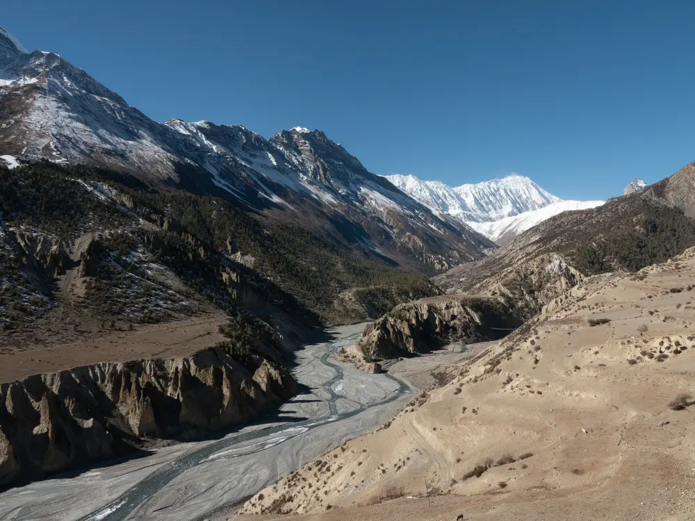
The Manaslu region is a quiet Himalayan area that has been important for many years, and people have used its trails for travel and trade. This same trails also lead to Serang Monastery, which is a peaceful place where monks live and follow old Buddhist traditions. Because of this, the route carries both cultural and spiritual value for the people who live here. The region is named after Mount Manaslu (8,163m), the eighth-highest mountain in the world, and these high mountains rise above valleys, forests, and uplands. The area is also known as “Kutang,” meaning the mountain of the soul, which shows how much respect locals have for the land. This respect led to a strict rule in the Manaslu Conservation Area that does not allow any animal to be killed inside the region. This tourism rule helps protect wildlife like red pandas, snow leopards, Himalayan tahr, and plants that grow here. As the trail moves higher, the villages slowly change, and their culture takes on Tibetan influence. This change is easy to see in places like Samagaon and Samdo, where the houses, language, and lifestyle show strong Tibetan influence.

Details

Manaslu Circuit Trek with Serang Monastery is worth visiting, as this trek brings nature, culture, and quiet walking trails together in one journey. Visiting Serang Monastery adds even more value to the trek because the monastery sits in a calm valley and shows the simple daily life of monks who still follow old traditions. Serang Monastery is located in Kyimolung Valley, also known as the “Valley of Peace and Happiness,”. The trail passes through the Manaslu Conservation Area, which helps keep the environment clean and protects rare animals, making the whole region feel peaceful and untouched. 

The trek also gives you a chance to see how people in high Himalayan villages live, especially those who have a close cultural connection with Tibet. Their homes, language, and lifestyle help you understand the history and culture of the region in a real way.  This route also includes the crossing of Larkya La Pass, which is one of the best viewpoints on the trek. From here, you can see wide views of the mountains and feel the true beauty of the Himalayas. For all these reasons, the trek is a great choice for anyone who wants to explore mountains, culture, and traditional village life in one trip.

Highlights

  • Trek through the Manaslu Conservation Area, home to red pandas, snow leopards, Himalayan tahr, and plants.

  • Visit Serang Monastery, a quiet and peaceful monastery that shows the daily life of monks and local Buddhist traditions.

  • Explore villages like Samagaon and Samdo, where houses, clothing, and culture reflect strong Tibetan influences.

  • Cross Larkya La Pass (5,160m), one of the most scenic and memorable points on the trek, with wide views of Himlung Himal, Cheo Himal, Kang Guru, and Annapurna II.

  • Experience a quiet trail with fewer trekkers, giving more space, calm moments, and a real connection with nature.

  • See Mount Manaslu (8,163m), the eighth-highest mountain in the world, rising above valleys and forests along the route.

Itinerary

Day 01: Arrival in Kathmandu

You arrive in Kathmandu, the capital city of Nepal, and be welcomed by our representative at the airport. After the check-in process at your hotel, you can take some rest after a long flight or wander around the lively streets of Kathmandu, exploring places like Thamel, Durbar Marg, and Ason Bazaar. In the evening, enjoy a warm dinner and prepare for the trek starting the next day.

  • Max Elevation: 1,400 meters (Kathmandu)

  • Travel Distance: 6 to 8 kilometers

  • Travel Hours: 20 to 30 minutes

  • Accommodation: 3 star standard Hotel

  • Meal: Dinner

Day 02: Explore Kathmandu Valley – Full-Day Sightseeing Tour

After breakfast, your day begins with a guided tour of Kathmandu Valley. A private vehicle is provided for the day, making travel smooth and hassle-free. Your local guide shares stories, historical details, and cultural insights at every stop. The schedule is relaxed, so you have plenty of time to enjoy each site without feeling rushed. During this tour, you explore some of the valley’s most famous cultural and heritage landmarks, each with its own story and significance.

1. Pashupatinath Temple
This temple is one of Nepal’s most important Hindu shrines, dedicated to Lord Shiva and located along the Bagmati River. While non-Hindus cannot enter the main temple, the surrounding area offers excellent views of the complex and the daily rituals. The temple’s traditional pagoda style and golden rooftops make it a remarkable sight.

2. Boudhanath Stupa
Boudhanath is one of the largest stupas in Nepal and a central place of worship for Buddhists. The stupa features the iconic Buddha eyes on all four sides. Walking around it, you can observe pilgrims spinning prayer wheels, chanting, and performing religious rituals.

3. Patan Durbar Square
In the heart of Lalitpur, Patan Durbar Square is renowned for its stunning Newari architecture. Explore the centuries-old palaces, temples, and courtyards built during the Malla period, showcasing delicate carvings and traditional craftsmanship.

4. Swayambhu Stupa (Monkey Temple)
Swayambhu Stupa sits on a hill and provides breathtaking views of Kathmandu city. Called the Monkey Temple because of the monkeys around the site, it holds religious significance for both Buddhists and Hindus. Visitors can enjoy the serene atmosphere while watching devotees perform rituals and spin prayer wheels.

  • Max Elevation: 1,450 meters (Swayambhu Stupa – highest point of the day)

  • Travel Distance: 25 to 30 kilometers  (total driving distance)

  • Travel Time: 6 to 7 hours

  • Accommodation: 3-Star Hotel

  • Meal: Breakfast

Day 03: Drive from Kathmandu to Machha Khola(900m/2953 fts/155km)

The drive from Kathmandu to Machha Khola takes you along the Dhadingbeshi to Aarughat road, covering about 160 km in 7 to 8 hours. Machha Khola is a small town next to the river. The peaceful feeling and smells of food make it a good place to stop. Up to Aarughat, the road is smooth and mostly black-topped, so the ride is easy. You can notice the mountains rising around you, especially Ganesh Himal, and the journey gives a clear view of the Himalayan landscape. 

  • Max Elevation: 900 meters (Machha Khola, the highest point between Kathmandu and Machha Khola)

  • Travel Distance: 160 kilometers

  • Travel Hours: 7 to 8 hours

  • Accommodation: Teahouse/Lodge

  • Meals: B,L,D and Hot drinks

Day 04: Trek from Machha khola to  Jagat (1410m/4626ft)

After breakfast, the trek begins with a short warm-up to prepare for the day. The trek from Machha Khola to Jagat covers about 22.2 km (13.8 miles) and takes around 6 to 7 hours. This trail passes through Khorla Besi and reaches Tatopani, known for its natural hot springs, which makes it a good spot to relax. From there, the path ascends gradually toward Jagat Village, crossing a few suspension bridges along the way. Jagat is a small Gurung settlement with about 40 houses, decorated with mani walls and stupas, showcasing traditional architecture.

  • Max Elevation: 1,410 meters (Jagat, the highest point between Machha Khola and Jagat)

  • Travel Distance: 22.2 kilometers

  • Travel Hours: 6 to 7 hours

  • Accommodation: Tea house/Guesthouse/Lodge

  • Meals: Breakfast, Lunch, Dinner, and Hot drinks

Day 05: Trek from Jagat to Deng (1804m/5919ft)

Leaving Jagat, the trek enters the Manaslu Conservation Area after completing the permit check. The trail passes through several villages, including Philim, one of the largest in the region, which has a health checkpoint and trekking office. Then the path continues to Pewa Village, moving gradually uphill. Along the way, you can see Shringi Peak rising above the valley and Ganesh Himal II and III in the distance. You can get a clear view of the mountains in Deng, while preparing for higher altitudes ahead.

  • Max Elevation: 1,804 meters (Deng, the highest point between Jagat and Deng)

  • Travel Distance: 20 kilometers

  • Travel Hours: 7 to 8 hours

  • Accommodation: Tea house/Guesthouse/Lodge

  • Meals: Breakfast, Lunch, Dinner, and Hot drinks

Day 06: Trek from Deng to Bhi Phedi/kwak Home stay (2130m)

From Deng, the trail takes you toward Bhi Phedi, passing through small villages covering 10 kms, in around 5 hours. Trekking through this section, the path moves steadily with gentle climbs, giving clear views of nearby peaks. These villages show traditional architecture and local culture, offering a glimpse of life in the region. The day ends at Kwak Home Stay or Bhi Phedi, providing a comfortable place to rest and prepare for the higher sections of the Manaslu Circuit.

  • Max Elevation: 2,130 meters (Bhi Phedi, the highest point between Deng and Bhi Phedi/Kwak Home Stay)

  • Travel Distance: 10 kilometers

  • Travel Hours: 5 to 6 hours

  • Accommodation: Tea house/Guesthouse/Lodge

  • Meals: Breakfast, Lunch, Dinner, and Hot drinks

Day 07: Trek from Bhi village/Kwak to Serang Monastery (3100m)

The trek from Bhi Village or Kwak to Serang Monastery covers approximately 12 km (7.5 miles) and takes around 7 to 8 hours. From there you head toward the monastery, which is located in the Kyimolung Valley. Serang monastery is a calm place showing traditional Tibetan Buddhist life. There is also an option to make a detour to visit Serang Monastery during the day without staying overnight. You can experience both cultural insight and  high-altitude trekking.

  • Max Elevation: 3,100 meters (Serang Monastery, the highest point between Bhi Village/Kwak and Serang Monastery)

  • Travel Distance: 12 kilometers

  • Travel Hours: 7 to 8 hours

  • Accommodation: Tea house/Guesthouse/Lodge

  • Meals: Breakfast, Lunch, Dinner, and Hot drinks

Day 08: Trek from Serang to Ghap (2160m/7085ft)

Journey continues from Serang Monastery toward Ghap, covering about 18 km (11.2 miles) in 7 to 8 hours. Ghap is a Sherpa village with tea house and lodge accommodation, where you can rest and enjoy meals.  While getting views of Shingri Peak and other nearby mountains, you pass through small villages and valleys. This section is moderate and gives a chance to experience local village life while preparing for the higher altitudes ahead.

  • Max Elevation: 2,160 meters (Ghap, the highest point between Serang Monastery and Ghap)

  • Travel Distance: 18 kilometers

  • Travel Hours: 7 to 8 hours

  • Accommodation: Tea house/Guesthouse/Lodge

  • Meals: Breakfast, Lunch, Dinner, and Hot drinks

Day 09: Trek from Ghap to Lho Village (3180/10433fts/10.5km/6.5mile)

Trek continues toward Lho Village from Ghap, covering about 16 km (9.9 miles) and taking around 4 to 5 hours. You trek through valleys and small settlements, giving views of Manaslu (8,163m) and nearby peaks such as Ngadi Chuli. Lho is a Tibetan-influenced village with traditional houses, mani walls, and a few tea houses for overnight stays. This section is shorter, allowing time to enjoy the scenery, experience local culture, and prepare for higher altitude trekking in the coming days.

  • Max Elevation: 3,180 meters (Lho Village, the highest point between Ghap and Lho Village)

  • Travel Distance: 10.5 kilometers

  • Travel Hours: 4 to 5 hours

  • Accommodation: Tea house/Guesthouse/Lodge

  • Meals: Breakfast, Lunch, Dinner, and Hot drinks

Day 10: Trek from Lho village to Samagaon (3530m/11582 fts/8.1km/5 mile)

Moving from Lho Village to Samagaon, the trek spans about 8.1 km (5 miles) and takes roughly 4 to 5 hours. You can get the best views of Manaslu (8,163m), Ngadi Chuli, and Shishapangma, when you pass through small and open valley areas. Samagaon is a quiet Tibetan-style village with traditional houses, mani walls, and local shops where you can interact with villagers. This shorter section allows time to rest, take in the scenery, and prepare for the acclimatization trek toward Manaslu Base Camp.

  • Max Elevation: 3,530 meters (Samagaon, the highest point between Lho Village and Samagaon)

  • Travel Distance: 8.1 kilometers

  • Travel Hours: 4 to 5 hours

  • Accommodation: Tea house/Guesthouse/Lodge

  • Meals: Breakfast, Lunch, Dinner, and Hot drinks

Day 11: Acclimatization day and detour to Manaslu base camp(4800m/15749ft)

From Sama, you can take a detour to Manaslu Base Camp to help acclimatize before higher altitudes. The round trip covers several kilometers and usually takes around 6 to 7 hours. While passing, you get close-up views of Manaslu (8,163m), Ngadi Chuli, and nearby peaks, glacial valleys, and rocky ridges. Returning to Sama in the evening gives time to rest, enjoy the village, and prepare for the next stage of the trek.

  • Max Elevation: 4,800 meters (Manaslu Base Camp, the highest point between Samagaon and Manaslu Base Camp)

  • Travel Distance: 14 kilometers (round trip)

  • Travel Hours: 6 to 7 hours

  • Accommodation: Tea house/Guesthouse/Lodge

  • Meals: Breakfast, Lunch, Dinner, and Hot drinks

Day 12: Trek from Samagaon to Samdo (3860m/12665fts/8.1km/5.03mile)

You have to cover a distance of about 8.1 km (5 miles), taking roughly 3 to 4 hours, to reach Samdo from Samagoan. Path towards Samagaon rises gradually, offering views of Manaslu (8,163m), Ngadi Chuli, and nearby Himalayan peaks. Samdo is a quiet Tibetan-style village where traditional houses, mani walls, and prayer flags show the local heritage. Locals maintain their Buddhist customs and daily rituals, giving a glimpse into their way of life. This part of the trek allows for acclimatization while giving a chance to explore the village and observe local traditions.

  • Max Elevation: 3,860 meters (Samdo, the highest point between Samagaon and Samdo)

  • Travel Distance: 8.1 kilometers

  • Travel Hours: 3 to 4 hours

  • Accommodation: Tea house/Guesthouse/Lodge

  • Meals: Breakfast, Lunch, Dinner, and Hot drinks

Day 13: Trek from Samdo to Dharamshala(4460m/14633fts/6.6km/4.10mile)

Covering 6.6 km (4.1 miles), the trail from Samdo to Dharamshala typically takes around 4 to 5 hours for the trek. This section passes through rocky glacier terrain above the tree line, offering clear views of Manaslu (8,163m) and surrounding peaks. You cross a stream from Giya La and reach Larkya Bazaar, an important trading point connecting Nepal and Tibet. Dharamshala is a simple settlement with basic lodging, where locals follow traditional customs.

  • Max Elevation: 4,460 meters (Dharamshala, the highest point between Samdo and Dharamshala)

  • Travel Distance: 6.6 kilometers

  • Travel Hours: 4 to 5 hours

  • Accommodation: Tea house/Guesthouse/Lodge

  • Meals: Breakfast, Lunch, Dinner, and Hot drinks

Day 14: Trek to Bhimthang via Larkya La pass (5106m/16752fts,24.5km/15.22mile)

This is the most challenging day of the trek, starting early around 4 AM to reach Larkya La Pass, which is the highest point at 5,106 meters. You have to cover around 24.5 km (15.2 miles), in 4 to 5 hours. The trail can be snowy and slippery, so trekking poles and headlamps are recommended. You get a clear view of the high mountains, including Manaslu, Cheo Himal, Himlung Himal, Annapurna II, Gyaji Kang, and Kang Guru, from Larkya La Pass. After descending about 1,400 meters, the trek reaches Bhimthang, a quiet resting place surrounded by towering peaks. 

  • Max Elevation: 5,106 meters (Larkya La Pass, the highest point between Dharamshala and Bhimthang)

  • Travel Distance: 24.5 kilometers

  • Travel Hours: 10 to 11 kilometers

  • Accommodation: Tea house/Guesthouse/Lodge

  • Meals: Breakfast, Lunch, Dinner, and Hot drinks

Day 15: Trek from Bhimthang To Goa village /Tilche(2300/7546 fts)

Trekking from Bhimthang toward Tilche and Goa Village covers 26 km (16.1 miles) and takes roughly 6 to 7 hours. Goa or Tilche is the last village with a road connection, and people here follow both Buddhist and Hindu traditions, giving the place a special mix of cultures. You will cross small streams and trek past tiny villages while seeing the mountains around you change. You have time to rest and notice local ways of life before heading to lower areas.

  • Max Elevation: 3,720 meters (Bhimthang, the highest point between Bhimthang and Goa Village/Tilche)

  • Travel Distance: 26 kilometers

  • Travel Hours: 6 to 7 hours

  • Accommodation: Tea house/Guesthouse/Lodge

  • Meals: Breakfast,Lunch, Dinner and Hot drinks

Day 16: Trek to Dharapani, Drive to Kathmandu and Pokhara

The final day starts with a short trek from Tilche/Goa Village to Dharapani, where the trail meets the road. From Dharapani, the journey continues by vehicle to Kathmandu or Pokhara, covering about 215 km to Kathmandu or 133 km to Pokhara in 9 to 10 hours. The drive passes through towns and rural areas, giving one last glimpse of the hills and valleys of Nepal. And the day ends with arrival in Kathmandu or Pokhara  and overnight stay.

  • Max Elevation: 1,860 meters (Dharapani, the highest point between Tilche/Goa Village and Dharapani)

  • Travel Distance: 215 kilometers to Kathmandu and 133 kilometers to Pokhara

  • Travel Hours: 1.5 to 2 hours trekking and 9 to 10 hours drive

  • Accommodation: Tea house/Guesthouse/Lodge

  • Meals: Breakfast,Lunch and Dinner

What's included

  • Two nights in Kathmandu and one night in Pokhara with breakfast included

  • All airport, hotel, and bus park transfers

  • Daily meals on the trek (breakfast, lunch, and dinner) with tea or coffee

  • Cozy and family-friendly tea house or lodge accommodation during the trek

  • Local or tourist transport from Kathmandu

  • Licensed English-speaking trekking guide

  • Guide’s salary, meals, insurance, accommodation, and required trekking gear

  • A well-equipped first aid kit carried by the guide

  • All required trekking permits (ACAP and TIMS) and necessary paperwork

  • All government taxes, local fees, and service charges

  • A farewell dinner in Kathmandu at the end of the trek

What's excluded

  • Domestic and international flights

  • Nepal visa fee

  • Medical or travel insurance

  • Personal expenses such as snacks, beverages, laundry, phone calls, or hot showers

  • Personal trekking gear and clothing

  • Extra meals or accommodation in Pokhara

  • Emergency costs such as helicopter evacuation or medical rescue

  • Entry fees for sightseeing in Kathmandu and Pokhara

  • Additional tips for guides or porters

User Review