Manaslu - Annapurna Circuit Trek For 24 Days

Tour Info

trip code

EN-025

Starting Point/ End Point

Kathmandu

Accommodations

Lodge/ Tea House

Max Altitude

5106m (Larkya La Pass)

Duration

23 days

country

Nepal

Trip grade

Strenuous

Activities

Trekking

Best Season

February, March, April, May, June, September, October, November and December

Overview

The Manaslu and Annapurna Circuit Trek is an  enjoyable trek that combines two of Nepal’s best trekking routes. Manaslu region is quieter and more protected, so you need five permits to enter: TIMS, Local Area Permits, Restricted Area Permit, and the conservation permits for both Manaslu and Annapurna. You walk toward the base of Mt. Manaslu (8,163m), visit Pungen Gompa, and cross the high Larkya La Pass at 5,106 meters. After completing the Manaslu part, the route continues into the Annapurna Circuit, one of the world’s most popular trekking routes. This region is a mix of river valleys, open paths, and many local villages. You can also get views of Annapurna, Dhaulagiri, and other nearby peaks. The route is well-developed with teahouses, making daily travel easier. 

Details

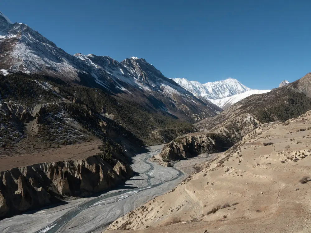
You can explore the Manaslu region, which is full of traditional villages, old monasteries, and strong Tibetan cultural influences. When you visit Pungen Gompa, you get to see an ancient Buddhist monastery, and local life in villages like Samagaon and Samdo. You can also enjoy views of Mt. Manaslu (8,163m) and surrounding peaks, and walk beside rivers, waterfalls, and glaciers. Moving toward the Annapurna region, you can see wide valleys, terraced fields, and small villages where local people farm and live. 

Slowly you come across Gurung and Tibetan traditions along the trail. You might see how families live, how prayer flags are placed, and how daily routines reflect their beliefs. You can also enjoy panoramic views of Annapurna, Dhaulagiri, and other high mountains. Along the way, you can visit peaceful places like Muktinath Temple, Birendra Lake, and small local chortens. As you move from the lower areas toward high passes like Larkya La and Thorong La, you get to see different landscapes.

Highlights

  • Cross two famous high passes of Nepal, Thorong La Pass (5,416m) and Larkya La Pass (5,106m).

  • Trek through changing landscapes, from warm forests and deep gorges to huge glaciers.

  • Visit the sacred Muktinath Temple and see its 108 holy water taps respected by both Hindus and Buddhists.

  • Stay in traditional Gurung and Tibetan village homes and feel the warm local hospitality.

  • Take in the beautiful mountain views of Annapurna, Manaslu, Dhaulagiri, Larkya Peak, Naike Peak, Siringi Himal, Ganesh Himal, and more.

  • Visit Pungen Gompa, meet local villagers, and explore the peaceful Birendra Lake.

  • Learn about local traditions, farming styles, and the daily lifestyle of villagers along the route.

  • Watch sunrise and sunset views that light up the snowy peaks in golden colors.

Itinerary

Day 01: Arrival in Kathmandu

On your arrival in Kathmandu, our team representative is there to pick you. Later in the evening, we have a short trip briefing at our office to go over your itinerary. You can spend the rest of the day exploring the sights, streets, and culture of Kathmandu.

  • Max Elevation: 1,400 meters (Kathmandu, city elevation on arrival)

  • Travel Distance: 6 to 8 kilometers

  • Travel Hours: 20 to 30 minutes

  • Accommodation: Tea house/Lodge

  • Meal: Breakfast, Lunch, and Dinner

Day 02: Full Day Guided Sightseeing Tour

Start your day with breakfast at the hotel, and get ready for a full-day tour around Kathmandu Valley. A private vehicle is arranged for the day, so you can travel comfortably between sites. A local guide accompanies you to share interesting stories, history, and cultural insights at each location. The tour is planned at an easy pace, giving you plenty of time to enjoy each place without rushing. During the day, you visit some of Kathmandu Valley’s most famous heritage sites, each reflecting the rich culture and traditions of Nepal.

1. Pashupatinath Temple
Pashupatinath is a major Hindu temple dedicated to Lord Shiva, located on the banks of the Bagmati River. While non-Hindus cannot enter the main temple, the temple grounds and rituals can be seen clearly from across the river. The temple’s classic two-tiered pagoda design and golden roofs make it one of the most iconic landmarks in Nepal.

2. Boudhanath Stupa
Boudhanath Stupa is one of the largest Buddhist stupas in the country. The stupa features Buddha’s eyes on all four sides, symbolizing wisdom and compassion. Visitors often walk around the stupa, spinning prayer wheels, and observe monks and pilgrims performing their daily prayers.

3. Patan Durbar Square
Located in the heart of Lalitpur, Patan Durbar Square is famous for its exquisite Newari architecture. The area is filled with ancient temples, palaces, and courtyards built during the Malla era, displaying intricate wood and stone craftsmanship.

4. Swayambhu Stupa (Monkey Temple)
Perched on a hilltop, Swayambhu Stupa offers stunning views of the entire Kathmandu Valley. Known as the Monkey Temple because of the many monkeys in the area, this sacred site is important to both Hindus and Buddhists. The peaceful surroundings make it perfect for observing prayers and soaking in the panoramic scenery.

  • Max Elevation: 1,450 meters (Swayambhu Stupa – highest point)

  • Travel Distance: 25 to 30 kilometers (total driving for the day)

  • Travel Time: 6 to 7 hours

  • Accommodation: 3-Star Hotel

  • Meal: Breakfast

Day 03: Drive from Kathmandu to Machha Khola (900m/2953 fts )

On the second day of the Manaslu–Annapurna Circuit Trek, you have to cover a distance of 155 km in about 7 to 8 hours to reach Machha Khola from Kathmandu. The drive starts early in the morning after breakfast. Along the way, you pass through small towns, local markets, and various checkpoints. After crossing the Malekhu River, you reach Dhading Beshi, the headquarters of Dhading District. You also can stop at Jyamire for a refreshing lunch. The journey continues through Taribeshi, Salyantar, Arughat, Arket, and Soti before arriving at Machha Khola at 900m along the Gandaki River. Here, you can relax and enjoy the calm area before starting the trek the next day.

  • Max Elevation: 1,400 meters (along the route, highest point before descending to Machha Khola)

  • Travel Distance: 155 kilometers

  • Travel Hours: 7 to 8 hours

  • Accommodation: Tea house/Lodge

  • Meal: Breakfast, Lunch, and Dinner

Day 04: Trek from Machha khola to Philim (1510m/4924ft)

The trek continues from Machha Khola to Philim, covering 27.2 km in about 7 to 8 hours. The route passes through small settlements and local villages, and the first stop is Korsani Village. From there, you follow the Budhi Gandaki River until you reach the Gurung village, located in Labishe. On the way to Philim, you can enjoy clear views of Ganesh Himal and Shringi Himal. The day ends with an overnight stay in Philim or Labishe at a tea house or lodge.

  • Max Elevation: 1,510 meters (Philim, the highest point between Machha Khola and Philim)

  • Travel Distance: 27.5 kilometers

  • Travel Hours: 7 to 8 hours

  • Accommodation: Tea house/Lodge

  • Meal: Breakfast, Lunch, and Dinner

Day 05: Trek from Philim to Ghap (2160m/7085ft)

From Philim to Ghap, the trek covers 28 km and requires about 7 to 8 hours of trekking to reach there. You also move along the Budhi Gandaki River toward Chisapani and you reach the junction of Shar Khola and the Tsum Valley. The path passes through small villages and bamboo forests. Then you reach Ghap, it is a village with Tibetan-style houses. People here follow their traditional way of life, and the village shows the living style of people in this part of the Manaslu region.

  • Max Elevation: 2,160 meters (Ghap, the highest point between Philim and Ghap)

  • Travel Distance: 28 kilometers

  • Travel Hours: 7 to 8 hours

  • Accommodation: Tea house/Lodge

  • Meal: Breakfast, Lunch, and Dinner

Day 06: Trek from Ghap to Lho Village (3180/10433fts)

The trek continues from Ghap to Lho Village, covering 16 km in about 6 to 7 hours. As you enter areas influenced by Tibetan culture, you can see vegetation and culture start to change. The trail passes through the mani walls and stone houses along the way. You can also see the mountains, like Mt. Manaslu (8,163m). After around 4 hours of walking, you reach Lho Village, where you can stay overnight.

  • Max Elevation: 3,180 meters (Lho Village, the highest point between Ghap and Lho)

  • Travel Distance: 16 kilometers

  • Travel Hours: 6 to 7 hours

  • Accommodation: Tea house/Lodge

  • Meal: Breakfast, Lunch, and Dinner

Day 07: Trek from Lho village to Samagaon (3530m/11582 fts)

The route from Lho Village to Samagaon, it is around 8.1 km and takes roughly 4 to 5 hours to complete. On the trail, you can see Ngadi Chuli Peak (7,879m) and Hiunchuli (7,893m). You trek through the village of Shyala and pass chortens, Gompas, and Tibetan prayer flags on the way. Then you reach Thosang Khola, from there the path goes down, and crosses a rocky area before reaching Samagaon at 3,530m.

  • Max Elevation: 3,530 meters (Samagaon, the highest point between Lho Village and Samagaon)

  • Travel Distance: 8 kilometers

  • Travel Hours: 4 to 5 hours

  • Accommodation: Tea house/Lodge

  • Meal: Breakfast, Lunch, and Dinner

Day 08: Acclimatization day and detour to Manaslu base camp (4800m/15749ft)

At higher altitudes, it is important to spend time adjusting before moving ahead. You can stay active by exploring Pugyen Gompa at 4,070m or take a short hike between Syaula and Sama. Another option you have is to visit Birendra Tal at 3,450m and, if you feel ready, continue to Manaslu Base Camp at 4,900m. North of Birendra Tal is Milarepa’s Cave, believed to have been used by the famous Buddhist saint for meditation.

  • Max Elevation: 4,900 meters (Manaslu Base Camp, the highest point on the acclimatization detour)

  • Travel Distance: 14 km (round trip from Samagaon)

  • Travel Hours: 6 to 7 hours

  • Accommodation: Tea house/Lodge

  • Meal: Breakfast, Lunch, and Dinner

Day 09: Trek from Samagaon to Samdo (3860m/12665fts/8.1km/5.03mile)

Trekking continues from Samagaon to Samdo, covering 8.1 km in about 3 to 4 hours. You move down to the Buri Gandaki River, passing the junction from Birendra Tal and Manaslu Base Camp. After around 2 hours of trekking, the valley opens up, and continues to the white Kani Gateway. It takes you to the entrance of  the Samdo Village at 3,860m. If you have time, you can also trek to the peak above the village for views of Mount Manaslu. For acclimatization, there is also an optional 6 to 7 hour hike climbing 640 meters to the moraine of Fukang Glacier. From there you have wide views of high passes used by locals to enter Tibet.

  • Max Elevation: 3,860 meters (Samdo Village, the highest point between Samagaon and Samdo)

  • Travel Distance: 8.1 kilometers

  • Travel Hours: 3 to 4 hours

  • Accommodation: Tea house/Lodge

  • Meal: Breakfast, Lunch, and Dinner

Day 10: Trek from Samdo to Dharamshala (4460m/14633fts/6.6km/4.10mile)

You have to cover around 6.6 km in 4 to 5 hours to reach Dharamsala from Samdo. The trail first goes down through fields before starting the climb toward Larkya La Pass, offering views of Mount Manaslu and the Syacha Glacier. You may spot Himalayan blue sheep on the way, while heading towards Dharamsala at 4,460m. This is the highest point you reach today, which is a stop before the pass to avoid altitude sickness.

  • Max Elevation: 4,460 meters (Dharamshala, the highest point between Samdo and Larkya La)

  • Travel Distance: 6.6 kilometers

  • Travel Hours: 4 to 5 hours

  • Accommodation: Tea house/Lodge

  • Meal: Breakfast, Lunch, and Dinner

Day 11: Trek to Bhimthang via Larkya La pass (5106m/16752fts)

The trail moves to Larkya La Pass at 5,106m, the highest point of the trek, covering 24.5 km in about 4 to 5 hours. It can be cold and windy, and snow may make the route challenging. You pass through many hills and cross an elevation leading to four frozen lakes before reaching the Larkya La Pass. From the top, peaks like Himlung Himal (7,126m), Cheo Himal (6,820m), Gyaji Kung (7,030m), Kang Guru (6,981m), and Annapurna II (7,937m) are visible. You then move west along a difficult section before the valley opens up and descends to Bhimthang at 3,720m, a historic trading post. A short detour above Bhimthang leads you to the glacial lake of Pungkar Tal at 4,100m.

  • Max Elevation: 5,106 meters (Larkya La Pass, the highest point of the trek)

  • Travel Distance: 24.5 kilometers

  • Travel Hours: 10 to 12 hours

  • Accommodation: Tea house/Lodge

  • Meal: Breakfast, Lunch, and Dinner

Day 12: Trek from Bhimthang to Tilche (2300m) or Dharpani (1900m)

From Bhimthang, you can descend toward Tilche at 2,300m or continue to Dharapani at 1,900m, covering about 26 km in 6 to 7 hours. You pass through small villages, forests, and terraced fields, giving a clear view of local life and traditional living practices. Landscape gradually opens as altitude decreases, with clear views of surrounding mountains. Tilche and Dharapani are important stopping points along the trail, there are tea houses and lodges where you can rest for the night.

  • Max Elevation: 3,720 meters (Bhimthang, the highest point between Bhimthang and Tilche/Dharapani)

  • Travel Distance: 26 kilometers

  • Travel Hours: 6 to 7 hours

  • Accommodation: Tea house/Lodge

  • Meal: Breakfast, Lunch, and Dinner

Day 13: Trek from Dharapani to Chame (2700m)

The trek continues through forests to Chame from Dharapani, a village with traditional Tibetan-style houses, covering part of the 15.5 km route that takes about 5 to 6 hours. The path slowly moves to the apple-growing area of Dhanaqi, where you can see farmlands and orchards along the way, with nice views of Lamjung and Annapurna II peaks. You pass through the villages of Ratamanang and Koto before reaching Chame at 2,700m. Trail then moves towards the Marsyangdi River , the district headquarters of the Manang region.

  • Max Elevation: 2,700 meters (Chame, the highest point between Dharapani and Chame)

  • Travel Distance: 15.5 kilometers

  • Travel Hours: 5 to 6 hours

  • Accommodation: Tea house/Lodge

  • Meal: Breakfast, Lunch, and Dinner

Day 14: Trek from Chame to Upper Pisang (3300m/10827fts)

Leaving Chame, trek through Telekhu Village on the 13.2 km route that takes about 5 to 6 hours to reach Upper Pisang. You can enjoy views of Annapurna and Pisang (6,091m) while trekking toward a suspension bridge, which crosses the Marsyangdi River. After crossing the bridge, it leads you into the upper part of the Manang Valley before reaching Upper Pisang at 3,300m.

  • Max Elevation: 3,300 meters (Upper Pisang, the highest point between Chame and Upper Pisang)

  • Travel Distance: 13.2 kilometers

  • Travel Hours: 5 to 6 hours

  • Accommodation: Tea house/Lodge

  • Meal: Breakfast, Lunch, and Dinner

Day 15: Trek from Upper Pisang to Manang (3520m/11549ft)

You can continue trekking towards Manang after you leave Upper Pisang, you have to cover 13.2 km in about 5 to 6 hours. You pass through Ghyaru village, known for its stone houses, and can enjoy views of Pisang Himal, Annapurna, and other nearby peaks. The path then leads to Ngawal, a village with a Gompa and old juniper trees. The trail descends slightly toward Mungji before reaching Manang at 3,520m, a well-known Thakali village.

  • Max Elevation: 3,520 meters (Manang, the highest point between Upper Pisang and Manang)

  • Travel Distance: 13.2 kilometers

  • Travel Hours: 5 to 6 hours

  • Accommodation: Tea house/Lodge

  • Meal: Breakfast, Lunch, and Dinner

Day 16: Acclimatization Day/Rest Day

Acclimatization day is very important to adjust your body to higher altitudes. You can take a short hike nearby to help your body adjust to the altitude. A popular option is a hike to Ice Lake at 4,620m, which takes you around 5 to 6 hours, as it offers views of the surrounding mountains. Another choice is visiting Milarepa Cave at 4,120m, a place of spiritual significance. These short treks help you acclimatize, and you can enjoy the natural beauty and peaceful surroundings of the Manang region.

  • Max Elevation: 4,620 meters (Ice Lake, the highest point on the acclimatization hikes from Manang)

  • Travel Distance: 12 km (round trip from Manang to Ice Lake)

  • Travel Hours: 5 to 6 hours

  • Accommodation: Tea house/Lodge

  • Meal: Breakfast, Lunch, and Dinner

Day 17: Trek from Manang Village to Tilicho Base Camp (4200m)

From Manang Village, you can continue trekking toward Tilicho Base Camp at 4,200m, you have to cover 20 km in about 7 to 8 hours. You follow paths that pass through rocky terrain and alpine landscapes, with views of surrounding peaks along the way. The climb gradually increases in altitude, giving you the chance to see glaciers and high mountain scenery. Reaching Tilicho Base Camp, you find a quiet area near the base of Tilicho Peak.

  • Max Elevation: 4,200 meters (Tilicho Base Camp, the highest point between Manang Village and Tilicho Base Camp)

  • Travel Distance: 20 kilometers

  • Travel Hours: 7 to 8 hours

  • Accommodation: Tea house/Lodge

  • Meal: Breakfast, Lunch, and Dinner

Day 18: Hike to Tilicho Lake (4,920m;3 hour) and return to base camp

You can hike to Tilicho Lake at 4,920m from Tilicho Base Camp, which takes you about 3 hours round trip, offering stunning views of the lake and surrounding peaks. After returning to the base camp, the trek continues toward Shree Kharka at 4,080m, covering 11 km in about 5 to 6 hours. The trail passes through rocky paths and alpine terrain, with opportunities to see high mountain scenery and small glacial streams. Shree Kharka is a quiet village where you can rest before continuing the journey the next day.

  • Max Elevation: 4,920 meters (Tilicho Lake, the highest point on the hike from Tilicho Base Camp)

  • Travel Distance: 11 kilometers (Tilicho Base Camp to Shree Kharka, excluding optional lake hike)

  • Travel Hours: 5 to 6 hours (excluding optional 3-hour round trip to Tilicho Lake)

  • Accommodation: Tea house/Lodge

  • Meal: Breakfast, Lunch, and Dinner

Day 19: Trek from Shree Kharka to Yak kharka (4,060m)

From Shree Kharka, you head to Yak Kharka at 4,060m, walking 8.4 km in roughly 4 to 5 hours. You walk through open highland areas with yak pastures and get views of nearby peaks and glaciers. The path passes small settlements where yaks graze, showing how people live in this high region. Yak Kharka is a quiet place to stop and rest before continuing the trek the next day.

  • Max Elevation: 4,060 meters (Yak Kharka, the highest point between Shree Kharka and Yak Kharka)

  • Travel Distance: 8.4 kilometers

  • Travel Hours: 4 to 5 hours

  • Accommodation: Tea house/Lodge

  • Meal: Breakfast, Lunch, and Dinner

Day 20: Trek from Letdar to Thorung High camp (4800m/15749ft)

The route moves from Letdar toward Thorung High Camp at 4,800m, taking around 4–5 hours to cover 9.5 km. Along the way, you pass rocky terrain and open alpine areas, with views of the surrounding peaks growing larger as you gain altitude. Small patches of snow appear on the path, and colorful prayer flags mark the route. Thorung High Camp serves as the final stop before the early morning crossing of Thorung La Pass.

  • Max Elevation: 4,800 meters (Thorung High Camp, the highest point between Letdar and Thorung La Pass)

  • Travel Distance: 9.5 kilometers

  • Travel Hours: 4 to 5 hours

  • Accommodation: Tea house/Lodge

  • Meal: Breakfast, Lunch, and Dinner

Day 21: Trek from High Camp to Muktinath (3700m) via Thorung La Pass (5416m)

You have to trek from High Camp to Muktinath via Thorung La Pass at 5,416m. It is one of the toughest days, also covering 15.6 km takes you about 7 to 8 hours. The higher altitude and strong winds make the climb challenging. Along the way, you may see yaks, sheep, and local traders carrying goods on mules or donkeys. At Thorung La Pass, you can enjoy impressive views of Annapurna, Gangapurna, and Khatungkang (6,484m). After the pass, the trail descends 1,600 meters toward Muktinath, with Mt. Dhaulagiri is visible in the distance as you continue.

  • Max Elevation: 5,416 meters (Thorung La Pass, the highest point on the route from High Camp to Muktinath)

  • Travel Distance: 15.6 kilometers

  • Travel Hours: 7 to 8 hours

  • Accommodation: Tea house/Lodge

  • Meal: Breakfast, Lunch, and Dinner

Day 22: Trek to Marpha (2680m) via Kagbeni village and Jomsom

By covering 24.4 km in about 5 to 6 hours, you reach Marpha from Muktinath, passing through Kagbeni and Jomsom. You walk through villages where Tibetan culture is still visible, with stone houses and small shops along the way. If needed, you can save a day by taking a local jeep or bus from Muktinath to Jomsom or even all the way to Pokhara. The path gradually descends, and the views of the mountains and river valleys change as you move lower.

  • Max Elevation: 3,700 meters (Muktinath, the highest point between Muktinath and Marpha)

  • Travel Distance: 24.4 kilometers

  • Travel Hours: 5 to 6 hours

  • Accommodation: Tea house/Lodge

  • Meal: Breakfast, Lunch, and Dinner

Day 23: Fly to Pokhara Drive from Marpha village to Pokhara (850)

You can take a short 20-minute flight to Pokhara or drive 145 km from Marpha, which takes about 7 to 8 hours. As you descend to 850m, the landscape changes from high mountains to gentler hills and rivers. In Pokhara, you can visit the beautiful Phewa Lake, where the calm waters reflect the surrounding mountains. Boating on the lake, enjoying views of the Annapurna range, and visiting the lakeside area are popular activities that make Pokhara a relaxing and scenic stop after the trek.

  • Flight Duration: 20 minutes

  • Max Elevation: 2,680 meters (Marpha, the highest point on the route to Pokhara)

  • Travel Distance: 145 kilometers

  • Travel Hours: 7 to 8 hours

  • Accommodation: Tea house/Lodge

  • Meal: Breakfast, Lunch, and Dinner

Day 24: Drive or Fly to Kathmandu

From Pokhara, you can either drive or take a flight back to Kathmandu. The drive covers 205 km and usually takes about 9 to 10 hours. Along the way, you pass through small towns, farmlands, and hills, seeing everyday life in the mid-hill region of Nepal. Arriving in Kathmandu at 1,350m, you return to the city’s bustling streets and can spend time exploring or relaxing after the long journey. This marks the end of the Manaslu–Annapurna Circuit trek and the mountain adventure.

  • Max Elevation: 850 meters (Pokhara, the highest point along the route to Kathmandu by road/flight)

  • Travel Distance: 205 kilometers

  • Travel Hours: 9 to 10 hours

  • Accommodation: Tea house/Lodge

  • Meal: Breakfast, Lunch, and Dinner

What's included

  • Pick up from and drop off to the airport in a private car and taxi vehicle

  • Two Night 3 star hotel in Kathmandu with B/B plan

  • All accommodations in lodges/tea houses during the treks

  • All standard meals (breakfast, lunch and dinner) during the trek

  • Transport-private jeep to Soti khola or Machha khola and Sharing jeep and local Bus to pokhara (local bus are available every morning )

  • All necessary paper works, Conservation entry permits, Manasalu special permit for 7 days and TIMS permit

  • An experienced professional english speaking Guide

  • Salary, Food, Drinks, Accommodation, Transportation and Insurance for the Guide

  • Welcome or Farewell dinner in Kathmandu in a typical Nepali restaurant with a cultural dance performance in the evening

  • Medical kit (carried by your trek leader)

  • Rescue operation arrangement in case of emergency conditions (funded by travel insurance)

  • United Nepal Treks N Tours duffel bag, sleeping bag(return), T-shirt and trekking map

  • All necessary paperwork and trekking permits (National Park Permit, TIMS)

  • First Aid Kit (carried by your trek leader)

  • All government taxes and official expenses

  • Guaranteed Departures

  • Lifetime Deposit

  • Hot drinks (tea and coffee 3 to 4 times in day)

  • Purified drinking water

What's excluded

  • International airfare

  • Nepal entry visa; you can obtain a visa easily upon your arrival at Tribhuvan

  • International Airport in Kathmandu

  • Travel insurance (if there is emergency)

  • Lunch and Dinner while you are in Kathmandu and Pokhara

  • Beverage (cold drinks and hard drinks)

  • Wifi, Battery charges, hot shower

  • Your personal expenses

  • City sightseeing and entrance fees (See sightseeing and entrance fees)

  • Flight ticket from jomsom-Pokhara-Kathmandu

  • Tips for the guide, porter & driver (Tipping is Expected)

  • Items and transportation are not included and mentioned in itinerary

User Review